Hi all, Monday, Oct. 3
Tonight was an added pot-luck dinner. It was planned around noon,
so I did not have time for my crock-pot dinner. Fortunately I had
bought an enchilada casserole which I cooked for dinner. After dinner
we had special entertainment. We held a roast for Floyd. We
had all prepared our talks ahead of time and had a lot of fun presenting
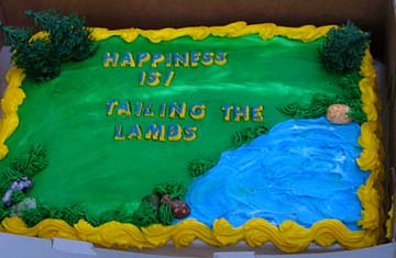
them. After the roast, we had a cake which was inscribed for the
Lambs, along with homemade ice cream the Eschers sent along when they had
to cancel coming with us due to mechanical problems. We also presented
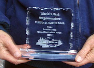
Floyd and Ruth with a beautiful clear plaque proclaiming them as the World's
best Wagonmasters. It was a lot of fun and I think everyone, including
Floyd, enjoyed it.
Tuesday, Oct. 4
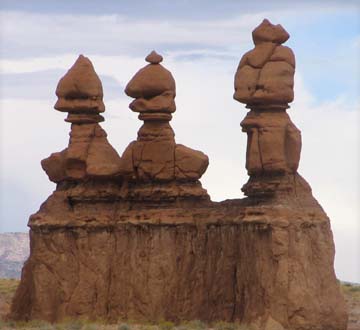
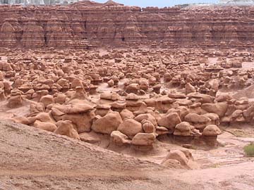
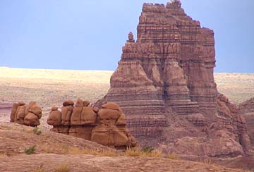
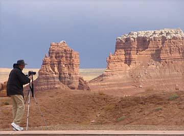
These "goblins" were formed because the Entrada Sandstone has very uneven hardness. The softer sections erode with wind and rain much more rapidly than the harder ones. This leaves shapes which become "goblins", "stone babies", and "hoodoos". After looking at the formations in a very cold, brisk wind, along
with a light driving rain, we decided to eat lunch in our cars. While
we were eating, the clouds started to thin and we actually had bright sunlight
at times.
By the time we arrived back at camp, the front had passed and the clouds were pretty much gone. The very cold wind was still here. We found the park is now filled with Discovery motorhomes. There must be over a dozen here, apparently on a rally. This evening we went to a local restaurant, the Cafe Diablo which specializes in South West cuisine. According to a writeup Jean has, it is the best in southern Utah. They had very unusual menu items. Everything was served items with very unique presentation. Norm's chicken plate looked like a chicken with a spray of greenery as the tail feathers. Merle's salmon dish looked like there were sea plants (narrow green tortilla chips) growing from the top of the stacked arrangement. Some of the dishes looked like there was a small tree growing from them. It was a lot of fun, and the food was very good. I had only an appetizer - rattle snake cakes. Made of 65% rattle snake, they were really quite good. This is our last day here at Torrey. Tomorrow we drive about 250 miles to Monument Valley. Wednesday, Oct 5
I pulled out of camp at about 8:20, about the 3rd or 4th to leave.
It was a beautiful trip with quite a bit of climbing and descending, and
a few tight turns. I passed the Lambs, the Johnsons, and the Bakers
in the Chevron station as I drove by. During the next 5 hours of
driving, I saw every other rig on the road except the Pullens. Traffic
was so heavy on Highway 95 that at mile marker 18 a car went by going the
opposite direction, and at mile marker 28 another one did, with none in
between.
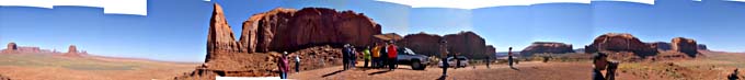
The Perdues, the Lambs, and I pulled into Gouldings RV Park, at around 1:30. over the next couple of hours the rest arrived. We cut our stay here from 6 nights to 5 nights, so I should be getting home a day early. This will give me 2 days before I have to head out again for my niece's wedding! I was encouraged as I had a good Verizon signal a couple times during the drive over here, but once again, there is absolutely no cell phone coverage here. The park does offer WIFI for 1/2 the price of the one at Torrey. At $3.00 a day, I will probably spring for a day or two during our stay here. We all met for snacks (AKA dinner) at 5:00 to discuss our plans for our stay here. There are several day drives to do, and we will investigate our options for touring Monument Valley with a Navajo guide. This evening I had 7 people over for a showing of the Johnsons' videotape
of the Mormon expedition team that in 1879 established a colony very near
here starting from Escalante, building a 200 mile long road through Hole-in-the-Rock
to the Colorado River, and across some of the roughest country in the world.
They completed it in about 6 months without losing a single life.
Two babies were born during the trip. The route they created was
used bi-directionally for about a year before an alternate route was made
by way of Hall's Crossing.
Thursday, Oct 6
We headed out in the cars this morning in a northeast direction.
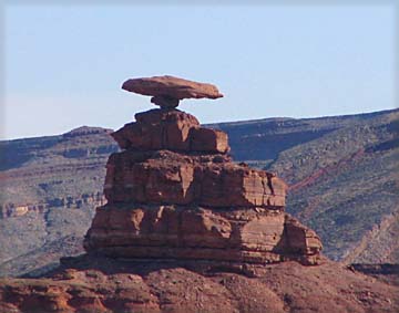
After about 20 miles we passed through the town of Mexican Hat. Just
out of town, we came to Mexican Hat Rock. This is a formation which
is topped by an upsidedown sombrero, balancing on a very small stem.
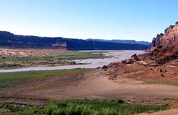
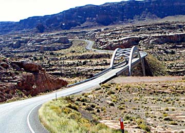
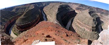
We backtracked part of the road we came in on until we reached highway 261 where we turned north. This road is a nice blacktop road until it reaches the face of a huge bluff, where it turns into a dirt/gravel road which climbs 1100 feet in 3 miles. It does this by a series of fairly tight switchbacks. Once you reach the top, the road turns back into a nice blacktop road. We continued on to Gooseneck State Park. This is an overlook of
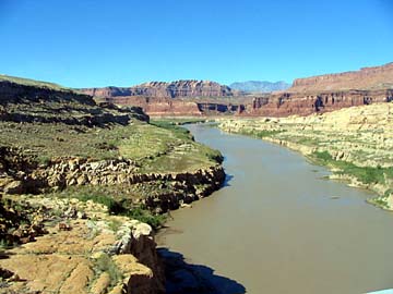
a section of the San Juan River where it meanders back and forth in a somewhat
W shape. It flows enters at the side heading straight toward you,
makes a sharp bend and flows away, makes another sharp bend and comes toward
you again, and makes one more turn and flows away from you on the other
side. It is very interesting, and very picturesque.
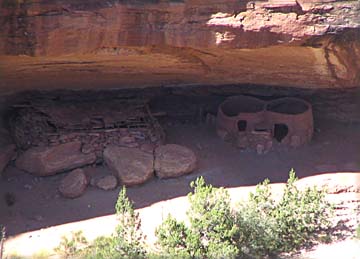
Next we continued on the Natural Bridges National Monument where we saw a video in the visitor center, then drove an 11 mile loop to a series of overlooks which allow views of 3 natural bridges and some ancient ruins. The 3 bridges covered the range from a very young bridge, a medium age bridge, and a very old bridge in the last stages of its life. These bridges are formed where the river has cut a channel and there is a switchback like at Gooseneck Park. As the water wears the wall from each side the divider rock gets very thin and eventually fails, creating a hole. Now the water will usually flow through the hole instead of around the former bend, eroding the hole even faster. Over the eons, wind, blowing sand, and rain continue to erode the stone, continuing to enlarge the bridge opening. This wear continues over the millions of years until finally the bridge is so thin it collapses. This is the end of its life. One of the stops was for a hike out to an overlook of the Horsecollar
Ruins. These ruins are in very good condition for having been occupied
by the Anasazi from about 1050 to 1300.
After lunch at a picnic stop on the loop road, we turned back toward
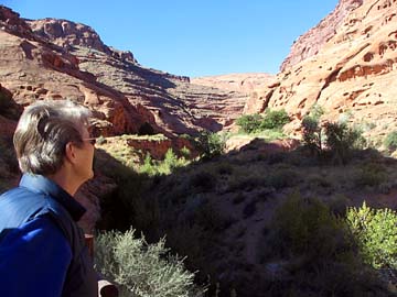
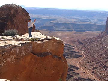
our camp, retracing our path of this morning. Just as we reached
the top of the gravel switchbacks, we turned off on a side dirt road to
Muley Point. When we arrived we were on the top of a number of hugh
rocks. Many of these had totally vertical sides down to the valley
floor far below. The views from here were spectacular! We could
see the top of a number of channels like the Goosenecks, but I am not sure
that is what they were.
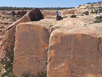
There was a huge rock that had obviously split off the main rock and
was now about 10 to 15 feet away, hanging over the valley below.
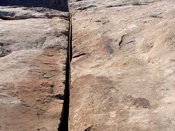
At one place there is a split in the main rock with a gap of 5 or 6 inches.
If you stand at the right point, you can look down through this crack and
actually see out through the cliff.
From here we returned to camp after being out all day. About an hour later, we left camp again for the lodge restaurant about a mile down the road. I had a Navajo Taco, which is like a tostada on Indian Fry Bread. It was delicious, and I have one more dinner of it yet to eat with what I took home. Tomorrow we will take a tour of Monument Valley on a Navajo guided truck. Friday, Oct 7
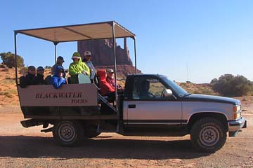
We were a little concerned at first, as this tour was about $10 more
for a 2 1/2 hour tour than the ones offered here at the campground.
The fellow who collected our money assured us it was well worth the difference
for a couple of reasons. First, Gouldings does not leave the 17 mile
loop that is open to anybody in their private cars, Blackwater Tours (our
tour company) goes to a number of places only Navajo tours can go.
Second Gouldings starts counting the 2 1/2 hours at the campground, Blackwater
starts when the loaded truck actually starts out on the tour road.
In addition, we ended up getting over a 4 hour tour.
There was no narration as we drove, but the driver would stop frequently
and tell us what we could see from where we were, and what to look for
ahead. We saw a number of beautiful formations we could not have
seen with the other tour or from our cars, as they went into several back
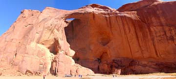
roads that were posted as off limits. We saw 4 arches on these back
roads. As we were nearing the end of the tour, he headed into a shady,
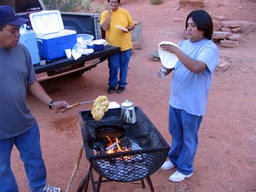
tree covered nook behind a large mesa. There were his partners cooking
over a wood fire in a grill. They were making Indian Fry Bread.
They hand formed a small ball of dough into about a 10 inch flat disk.
They would punch a hole in the center to vent the cooking gasses, and drop
it into the boiling oil on the fire. After a minute or so, he would
flip it and cook the other side. As it cooked it would puff up making
a finished piece of fry bread that was 1 to 1 1/2 inches thick in places.
It was very good. They kept cooking until everyone who wanted one
had his own piece. Of course there was a lot of sharing as this process
continued. Every once in a while, the cook would make a tortilla
by placing the dough directly over the coals, skipping the oil.
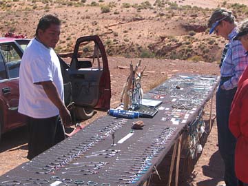
While we were there, they told us that the 3 of them were all cousins and partners in this tour company. They started it only 2 months ago. They have two tour trucks so far and hope to expand as the finances allow. They can only give tours about every other day, as there are 12 companies offering tours, but the tribe only allows 6 to operate on any given day. By the time we returned to the visitor center, we had been gone over 4 hours. This turned out to be an excellent choice of tour companies! After a couple hours of relaxation, we all met for our White Elephant auction. In Gordon Boyce's absence, Norm was the auctioneer (and did an excellent job). All told, the items we auctioned brought over $100 to help pay for Floyd's Fabulous Prizes (given to the winners of various games) and postage. We found out today that Norm and Jean have to leave early to stop by their home before they head north for a reunion. They will leave early tomorrow morning. We shall miss them! I expect to buy some Internet access tomorrow after we return from our drive, so I will finish this report here. You can see this report and my other reports along with a number of photos at: http://myweb.cableone.net/rsmason Till next time, Dick |
||||||||||||||||||||||||||||||||||||||||||||||||||||||||
|
Dick Mason, Prescott, AZ 10/07/05
|